Where is SABA island ? ?

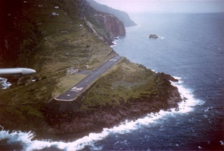
     On the attached map, you can see it NorthWest of Guadeloupe and EastSouthEast of Puerto Rico. Ranked as National Geographic among Top 10 Islands , this small, 12-square-kilometer island with a tropical rainforest is the tip of a sleepy volcano (at least nowadays) that rises to 870m (nearly 3000ft) above sea level. It is the smallest of the islands of the Netherlands Antilles, which does not prevent it from hosting the highest mountain of the Netherlands called mount Scenery. With no beaches, its steep topography is a well-defined characterization of a volcano summit.
     A single road (aptly-named 'The Road') which was built over a long period of time from 1938 to 1958, leads to picturesque villages known as 'The Bottom' or 'Windwardside'.

     Juancho E.Yrausquin Airport on the island of Saba is very little known though it is considered one of the most original and spectacular airports in the world. It is ranked by National Geographic as the world's second-most "extreme" airport ( world's most extreme airport ) after that of Ross Island in Antarctica, which is built on sea ​​ice. With cliffs at both ends and swept by strong crosswinds, its runway almost identical in length to that of the largest US Navy aircraft carriers (class Nimitz) arouses the interest of thrill-seekers : thousands of visitors do not hesitate to take the air route to reach an island that, unlike its neighbors, does not have white beaches lined with coconut trees. Only Short Take-Off and Landing (STOL) aircrafts such as the Twin Otter are allowed to come to this airport.